|
|
Hydrogeology
of the
Kern River Alluvial Fan
(The water supply of Bakersfield)
Click here for more info on the Kern River
 Most of the Kern County water supply comes from huge subterranean reserves of groundwater stored beneath fertile farmlands of the San Joaquin Valley. Although the valley has been compared to a huge underground lake, it is actually a rather porous body of loosely packed river sands and gravels, called alluvium. Most of the Kern County water supply comes from huge subterranean reserves of groundwater stored beneath fertile farmlands of the San Joaquin Valley. Although the valley has been compared to a huge underground lake, it is actually a rather porous body of loosely packed river sands and gravels, called alluvium.
Although the upper 200 feet of the valley alluvium is saturated with groundwater, only a little over 7% of this interval is actually water. This does not seem like much, but it equals about 93 million cubic feet of water-enough water to fill the man-made reservoir at Lake Isabella, in the mountains above the valley, to the spill point of the Isabella dam more than 163 times.
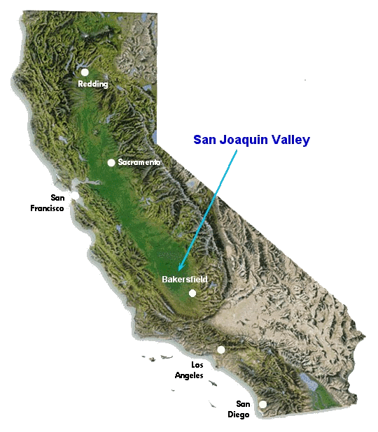
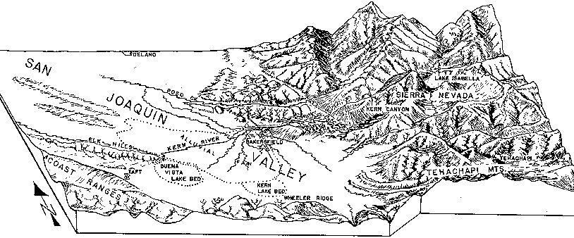
 Bakersfield, in particular, has an abundant supply of groundwater. This is due largely to the Kern River alluvial fan, which is a huge fan-shaped wedge of sand and gravel on the east side of the valley that forms where the Kern River exits out of the Sierra Nevada foothills. Here, the river flows across the Kern River fault and undergoes a dramatic change in slope as it spreads out from the confines of the Kern River Canyon onto the grasslands of the southern San Joaquin Valley. Deposition of the alluvial fan is the geologic response to this change in slope and to the transition from confined to unconfined flow. Bakersfield, in particular, has an abundant supply of groundwater. This is due largely to the Kern River alluvial fan, which is a huge fan-shaped wedge of sand and gravel on the east side of the valley that forms where the Kern River exits out of the Sierra Nevada foothills. Here, the river flows across the Kern River fault and undergoes a dramatic change in slope as it spreads out from the confines of the Kern River Canyon onto the grasslands of the southern San Joaquin Valley. Deposition of the alluvial fan is the geologic response to this change in slope and to the transition from confined to unconfined flow.
Water runoff from the Sierras flows from NE to SW down the bed of the Kern River onto the alluvial fan where the water slowly seeps from the river bottom into the distant margins of the fan. Elk Hills, which represents the surface expression of a giant subsurface anticline that rises out of the central part of the valley, then diverts this subsurface flow southward towards Buena Vista Lake (see below).
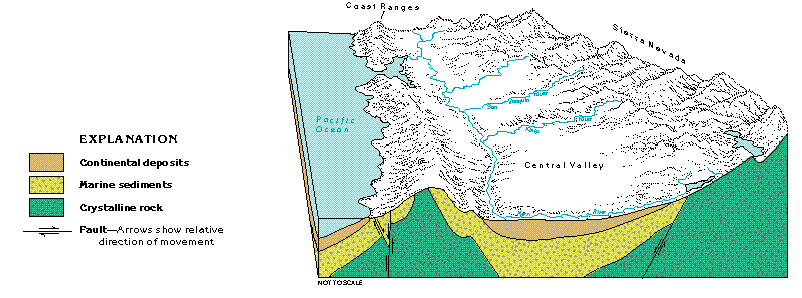
The near-surface water reservoir, which is called an aquifer, is made up of Pleistocene to Recent sands and gravels of the fan itself. These alluvial sediments cut into older alluvial fan and lake (lacustrine) sediments of the Plio-Pleistocene Tulare Formation. An angular unconformity then separates this thick pile of continental sediments from underlying marine deposits of the Pliocene San Joaquin Formation (see the valley cross-section below).
(click the cross-section to learn more about it)
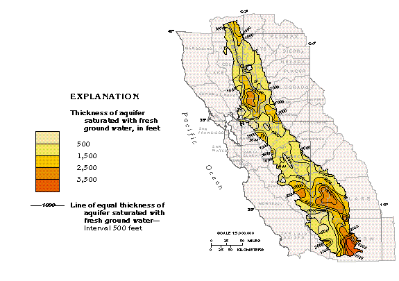
The water-saturated aquifer that the Kern River fan is part of is hundreds of feet thick. Bakersfield actually straddles a sort of east-to-west trending subsurface ridge, called the Bakersfield Arch, which separates northen and southern basins where the aquifer is thousands of feet thick (see the aquifer thickness map below). The northern basin is known as the Buttonwillow depocenter. The southern basin, which is the thicker of the two, is called the Tejon, and sometimes the Maricopa, depocenter.
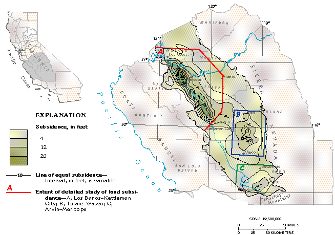
 Although rapid withdrawal of groundwater by water wells since the 1920s has resulted in subsidence of as much as 8 feet in the area immediately east of Maricopa, the Bakersfield area has experienced only minor subsidence. The primary cause of subsidence in the southern part of the valley is compaction of clays when wells withdraw groundwater from the aquifer faster than the aquifer can be recharged through surface runoff. Because Bakersfield is fed by abundant runoff from the Kern River fan, recharge is not a problem. By marked contrast, some areas of western Fresno County have experienced as much as 30 feet of subsidence from rapid pumping of the groundwater (see the valley subsidence map below). Although rapid withdrawal of groundwater by water wells since the 1920s has resulted in subsidence of as much as 8 feet in the area immediately east of Maricopa, the Bakersfield area has experienced only minor subsidence. The primary cause of subsidence in the southern part of the valley is compaction of clays when wells withdraw groundwater from the aquifer faster than the aquifer can be recharged through surface runoff. Because Bakersfield is fed by abundant runoff from the Kern River fan, recharge is not a problem. By marked contrast, some areas of western Fresno County have experienced as much as 30 feet of subsidence from rapid pumping of the groundwater (see the valley subsidence map below).
Two basic groundwater types characterize the area between Elk Hills and Bakersfield:
- Bicarbonate-rich (HCO3-) waters derived from the Sierra Nevada, on the east side of the valley, infiltrate from the Kern River throughout fan.
- Sulfate-rich (SO4-) waters from the Coast Ranges, on the west side of the valley, that infiltrate into the fan from surface runoff.
There are several processes in the Kern River fan that transform the east- and west-side groundwater end members into several compositionally distinct groundwater types:
- Groundwater in the fan with high salinity and total dissolved solids (TDS) generally results from mixing of pristine groundwater with descending evaporative brines formed in Buena Vista Lake. High salinity and TDS can also result through mixing of groundwater with oil field brines that infiltrate into the fan from unlined sump pits. Brine may also be injected into the aquifer by shallow, oil field disposal wells.
- Cation exchange at depth tends to concentrate Na at the expense of Ca.
- Pesticide or fertilizer contamination elevates nitrate and/or arsenic levels.
- Fluid-rock interactions in the alluvial fan may also release arsenic into the aquifer.
Fortunately, contamination by oil-field brines, pesticides or fertilizers in the Bakersfield area is minor, and most groundwater alterations in this part of the valley result from natural processes.
 Arsenic in the Kern fan is one contaminant that derives mostly from natural processes. Erosion in the Sierra Nevada delivers to the alluvial fan granitic and volcanic rocks that contain arsenic, and dissolution of these rocks by moving groundwater liberates the arsenic. Also, ferric hydroxides, an abundant weathering product of these types of rocks, adsorb arsenic at low pH (acid conditions) and lose their sorptive properties as pH increases (alkaline conditions). Dissolution of most rocks elevates groundwater pH and stimulates the release of additional arsenic held by ferric hydroxides. Arsenic in the Kern fan is one contaminant that derives mostly from natural processes. Erosion in the Sierra Nevada delivers to the alluvial fan granitic and volcanic rocks that contain arsenic, and dissolution of these rocks by moving groundwater liberates the arsenic. Also, ferric hydroxides, an abundant weathering product of these types of rocks, adsorb arsenic at low pH (acid conditions) and lose their sorptive properties as pH increases (alkaline conditions). Dissolution of most rocks elevates groundwater pH and stimulates the release of additional arsenic held by ferric hydroxides.
High arsenic levels characterize some dry lake basins, and arsenic appears to concentrate in the center of the valley along the north margin of Buena Vista Lake basin. However, arsenic does not appear to increase towards the basin center. Apparently, arsenic accumuates on the north side of the lake in a mixing zone between saline groundwater, derived from the lake to the south, and bicarbonate waters, derived from the Kern fan to the north. Arsenic delivered to the basin by the Kern fan derives from fluid-rock interactions that liberate arsenic from granitic rocks, intermediate volcanics, and ferric hydroxides. Because this arsenic dissipates with difficulty into saline groundwater of the lake basin, more arsenic enters the system than leaves. This results in concentration of arsenic in the mixing zone.
 Although the presence of arsenic at the foot of the fan is interesting, it is not a concern for Bakersfield since the city draws its water from the mouth of the fan, far removed the mixing zone. In fact, Bakersfield goundwater is unusually pure due to rapid recharge from the Kern River. Simply stated, groundwater in the upper part of the Kern fan does not linger there long enough to significantly alter the water chemistry. Although the presence of arsenic at the foot of the fan is interesting, it is not a concern for Bakersfield since the city draws its water from the mouth of the fan, far removed the mixing zone. In fact, Bakersfield goundwater is unusually pure due to rapid recharge from the Kern River. Simply stated, groundwater in the upper part of the Kern fan does not linger there long enough to significantly alter the water chemistry.
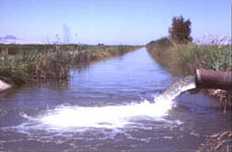
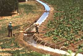 All in all, active inflow of groundwater (recharge) into gravels of the Kern River alluvial fan, a very porous aquifer, by runoff from the Sierra Nevada insures that Bakersfield will have an abundant supply of fresh, clean groundwater for many years to come. Although the river bed that winds through town is often dry, the water is still there - most of it being diverted to five major irrigation canals run through town. Today, water that once seeped into the ground through the old river bed now infiltrates into the fan alluvium from farm fields watered by smaller irrigation canals that run off these five main canals. Dig a hole twenty feet deep anywhere in the southwest part of town and the bottom of the hole will fill with water to form a pond - testament to the shallow level of the water table that Bakersfield is blessed with. All in all, active inflow of groundwater (recharge) into gravels of the Kern River alluvial fan, a very porous aquifer, by runoff from the Sierra Nevada insures that Bakersfield will have an abundant supply of fresh, clean groundwater for many years to come. Although the river bed that winds through town is often dry, the water is still there - most of it being diverted to five major irrigation canals run through town. Today, water that once seeped into the ground through the old river bed now infiltrates into the fan alluvium from farm fields watered by smaller irrigation canals that run off these five main canals. Dig a hole twenty feet deep anywhere in the southwest part of town and the bottom of the hole will fill with water to form a pond - testament to the shallow level of the water table that Bakersfield is blessed with.
Click here for more info on the Kern River
Further Reading
- Bertoldi, G.L., Johnston, R.H., and Evenson, K.D., 1991, Ground water in the Central Valley, California--A summary report: United States Geological Survey, Professional Paper 1401-A, 44 p.
- Dale, R.H., French, J.J., and Gordon, G.V., 1966, Ground-water geology and hydrology of the Kern River Alluvial-Fan area, California: United States Geological Survey, Open-file report, 92 p.
- Ireland, R.L., 1986, Land subsidence in the San Joaquin Valley, California, as of 1983: United States Geological Survey Water, Resources Investigations Report 85-4196, 50 p.
- Maher, J.C., Carter, R.D. and Lantz, R.J., 1975, Petroleum geology of Naval Petroleum Reserve No. 1, Elk Hills, Kern County, California: United States Geological Survey, Professional Paper 912, 109 p.
- Page, R.W., 1986, Geology of the fresh ground-water basin of the Central Valley, California, with texture maps and sections: United States Geological Survey, Professional Paper 1401-C, 54 p.
- Swartz, R.J., 1995, A study of the occurrence of Arsenic on the Kern Fan Element of the Kern Water Bank, southern San Joaquin Valley, California: Unpublished Masters Thesis, California State University, Bakersfield, California, 138 p.
- Williamson, A.K., Prudic, D.E., and Swain, L.A., 1989, Ground-water flow in the Central Valley, California: United States Geological Survey, Professional Paper 1401-D, 127 p.
- USGS Groundwater Atlas of the United States-Central Valley Aquifer System of California (website):
http://pubs.usgs.gov/ha/ha730/ch_b/index.html.
|

|